Tag Archives: best topo maps

Bwana Bubba’s Thoughts – You just have to ask!

Just asking you might gain access…

Getting permission to hunt a parcel of land is just like being a salesperson. If you don’t ask for the sale, most customers don’t think you care…   You won’t get the Sale!

2017 is know ahead for all of us to hunt.  The 2nd Amendment is safe.  Most states have the 2017 Hunting Regulations out.  Doing your research early, before having to put your applications can lead to success.  Scouting prior to application deadline and or long before your chosen hunt unit is critical for success.   I write and talk about onXmaps HUNT all the time about being one of the great keys to un-lock hunting success.  It is all true!  To be one of the 10% that take 90% of the game, then you have to absorb the positive and proven tips that are given to to by the successful 10%…

I want you to think about this scenario, you have been driving by a ranch, vineyard, farm, tree farm or just some private harvested timber land.  There are No Trespassing Signs and No Hunting posted on fence posts and trees, with game animals abounding and you notice a number of Coyotes working the area.  The signs have no phone numbers or names.  What to do you ask yourself, there is no way I am gaining access to hunt…  

There are many ways to get it done and as great salesperson you can make it happen in many cases.  First off I would purchased  onXmaps HUNT and have it on your Smart phone,  I suggest to have a Garmin GPS (colored screen-micro SD chip slot) also.

Working the different parcels of privately own properties your interested in, you will know the land owner’s name/names and in some cases the Trustee because you have onXmaps HUNT.   Now via Whitepages, and other public knowledge websites, you can get the phone number.  Relax, take a breath and be sure you have a smile on your face when talk on the phone…

Getting out early to scout prior to the season, you can find the game, such is the case with Rocky Mtn bull that was sleeping.

So many times over the course of life, I meet people while in the field, so asking who owns the land when you see a neighbor, should be no big deal.  Even going so far asking the neighbor how can I get a hold of the landowner is not out of the question.  Many times in the remote area, there might b an old cafe or gas station.  Another great way to gather information.

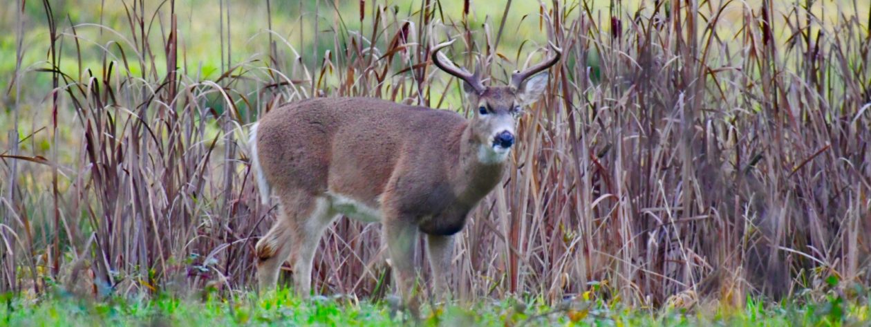
This Willamette Valley Blacktail buck was on private property that I gained access to. He was harvested the following year from this picture. 3X3 w/eye guards are fairly typical in Blacktail deer.

For many years I drove by a large piece of rural land that was growing wild radishes.  I thought they were weeds. I would see a couple of B&C and many P&Y Willamette Blacktails.  Finally when I got my first sample of HUNTINGGPSMAPS (onXmaps HUNT) from the company, I was able to dial in the future vineyard owner’s name.  I did a little background on the owner to make sure I had the correct person.  I called and told the owner that I drove by his place almost everyday.  That I would love to be able to take pictures of the deer on the property.  I asked permission to be able to photograph first.  It was early May, within  couple of months noticing the Coyotes and that he had chickens and geese free ranging, I called him again, I told him I could help reduce the Coyote population.  Finally in early August I asked for permission to bow for the deer.  I was informed by Michael (owner) that he intended to raise grapes.  In the State of Oregon to have venue events, you need a vineyard…  The following year with a rifle tag and bow tag, I asked if I could hunt deer with a rifle.  That privilege was also granted.  It also help to have a common bond.  Micheal was a Combat Engineer in Nam and I was a Navy Spook attached to the Marines in Nam. Brothers…

You have to remember that not all ranchers, farmers, and landowners are in it monetary when it comes to hunting.  I would bet that if a landowner is approached in the proper mindset, permission would be granted more times than rejected. 

This Oregon Mule Deer buck worked both B.L.M. and private land.

Over the years, hunters that I have met and talked to about the subject, give me back positive feedback.  Yes sometimes  they mend fences, bring a bottle, bring Salmon, ride a fence line, give a knife, buy dinner in town, but that is from the heart to a new friend.  Myself, I have hunted more ranches and farms than I can count. Many have border public land that I primarily hunt or fish during my lifespan! I have never paid cash for access, yet at certain times of the year, they might have something on their doorstep…

Use onXmaps HUNT products to gain the knowledge to gain access to private land.  It also will be the tool to know the landowners that border public land and vice versa.

IF YOU DON’T ASK, YOU’LL NEVER KNOW!

Frank Biggs aka Bwana Bubba


Bwana Bubba’s Thoughts – Timber Companies Charging Access

This article is a two part article that has to do with

Public Land Access and Private Timber Land Access

Changing times are upon us!

The following article are my thoughts and opinions on the subject public and private timber land use!
The new 21st Century Sign

Like the wind, the environment of hunting changes without notice.  Over the many years of hunting and being able to hunt openly on State, Federal, B.L.M. and Timber company’s properties, plus horse trading to hunt private, it was pretty easy to find a place to hunt without hassle in Oregon.

Not too many years ago I or We were able to hunt a great parcel of BLM in central Oregon near Madras, Oregon.  Since the land was rugged we would use quads to get from point A to B, glass and then hunt the game down.   Prior to quads from the days of hunting the great Snake River for Rocky Mountain Elk, horses were the key to non-motorized entry for our team.

A number of years ago the neighboring landowners were able to get the rules changed with BLM; no quads or other motorized allowed.  Strange that there are many old ranch roads and BLM roads on the land, now closed to the public, yet the adjacent land owner can use quads…  Just as strange motorized is allow on another parcel BLM land very close by.  The BLM is connected actually by a county line to the south.   I will tell you it was not a rancher or farmer that lobbied to get it closed!

Wanting to find new lands on the west side of the Cascades Mountains in Oregon, using my Garmin Montana GPS and the fabulous onXmaps HUNT software a new world open when scouting, finding such lands as Weyerhaeuser, Port Blakely, Longview Fiber (NOW OWNED BY WEYERHAEUSER), BLM, State Lands, plus small parcels of National Forest.  Mainly interested in Blacktail Deer though Roosevelt Elk can be found on the same land, scouting during May, June and July before the Oregon Archery season, it was great to find many great Blacktail bucks.

As you can see there is BLM and Longview Fiber (owned by Weyerhaeuser now), one might not be able to hunt the BLM any longer.

With regular maps you would never know the private timber conglomerates, yet alone small parcels of state owned or National Forest lands without using the onXmaps software.  In many western states there are mining claim that the public can pass through, but there are many small land parcels (50 – 200 acres) of mines on BLM and National Forest that you’ll never see on a paper map. Miners don’t take to kindly to trespassing and they might not call the law to Enforce a trespassing law…

Port Blakely allows some free hunting, but one better know the phone number and check prior to the dates wanting to access the land.  I am going to give a Hoorah to PLUM CREEK, as they allow the public to use their land with NO CHARGES.
This is where it stops; recently I made a call to an old hunting buddy about his elk hunt during the archery season in Oregon.  I was informed he received a $350.00 fine for trespassing on Weyerhaeuser property during the season.  What!  An area he has hunted for more than 30+ years for elk and deer.
For years the Weyerhaeuser properties have been open to public access. Well things change and now you have to have a permit to hunt.  A number of ways to do it, open permits or bid on the total access to parcels.
Stop and think about it for a second, most likely these giant timber companies get tax breaks and I can tell you some it about public access.  In the N.W. Weyerhaeuser owns 6,000.000+ acres, the size of Rhode Island in the United States and controlling 12,000,000 acres in Canada on long term leases.
There is now great controversy about Weyerhaeuser charging for access to their lands.
If you go back far enough you’ll find some of the tainted realities of land grab, via the railroads, government and the buying and giving of our timberlands.”  I remember the term cut and pay as you go.”  Think about making revenue without paying first, well in the timber business it has been done.

For years I have vented my thoughts and anger about BLM and other public land trades, in which there might be blocks of separated lands. What I have seen and many others that fight for our public lands are normally bad changes, with the public getting short end of the stick.

There should be an easy fix on this one.

There is one large section of BLM in Oregon in which some our most liberal politicians want to swap great elk and deer hunting land with a group.  In the rules of engagement of this particular land swap the two private land owners want to control the road, closing it off during the winter months. They want the county road to be vacated. The swap itself isn’t too bad, but the old wagon road from the 1800’s needs to be the dividing line with open access to the public. No one private individual should have the rights to stop the public from going into public land on a trade such as this.

We find that the National Forest wants to close thousands of miles of roads in the Wallowa-Whitman National Forest; the battle goes on with this subject!

So where is all of this leading, well it is leading into a fight for survival of hunting and public access to public land.  In the meantime it is very important for land users, whether fishing, hiking, hunting or evening just driving around to know the lay of the un-marked lands.  No matter who you are you need a Garmin GPS (colored-microchip capabilities-modern) and the onXmaps HUNT software loaded on the GPS and my personal recommendation on your laptop and your mobile device.  I have said since mapping GPS’s came out it is better to know where you are going then to know where you have been.  I love to search via onXmaps HUNT (APP) Google Earth and see new spots, thus adding them to my GPS for the next outing to investigate.

In Conclusion:  There are some private timber companies in the west and mountain states that allow the public to use their property for recreation.  It is important for everyone to know where they are and not take for granted they have access.  Use equipment that will keep you legal, safe and open new avenues in your outdoor ventures. Make your voice go forward about what is right!  Please remember that it is illegal to try and jump from corner to corner on public land that is encompassed with private…

I personally do not leave home without my Garmin Montana and my onXmaps HUNT updated for travels in Oregon!

Bwana Bubba


Hunting Benefits – GPS Global Positioning System

First off I can read a map, Military Training and the days of only having paper maps, but these days paper is for backup only, as GPS systems are so accurate and what they have to offer, such as backtracking, there is no way I would leave home without one!

In the old days the Global Positioning Systems could tell you where you have been via way-points and tracks.  

Oh! One could plug in coordinates, but it still was a plot system.  I use my laptop with mapping software all the time to locate new spots and then viewing it with Google Maps.   If I have something good that I want to venture it is loaded to my Garmin GPS with mapping.

I have updated this POST with new Mapping Software that will enable the Hunter and Outdoors person the freedom to not have to look over your back and wonder if you are hunting public property.  Recently I have put new mapping software to my Garmin Map Source on my Laptop and then download to the Micro SD Card that is in the slot on my Garmin Oregon 300.

New Garmin Montana with picture on screen


With this software you will be able to see BLM, State Lands, City Lands, Private Lands and National Forest Lands and Timber Company Lands are also on the software.   Being I am in Oregon I went with the OR-PLAT4GPS.  It is almost unbelievable what you see.    I fee that everyone should have a Garmin that has a color screen, high sensitivity antenna and capabilities to accept a Micro SD Card.

cf-lg.jpg
Garmin Rino 520HCX – 2 way FRS/GMRS – Topo GPSNew Garmin Montana with picture on screen

 Now the GPS can tell you where you have been, where you want to go and how to get there.   It is like looking at a TV and understanding what you have in front of you.  With the TOPO maps a GPS it can greatly make you get a gripe on the reality of using the GPS in the field.  

 If you understand Topo maps, you can identify with the lay of the land.  Be able to find the shortest way out using the GPS.    These days I can look at a map, have an idea of a place I have heard about or I want to visit.  Plug it in, even go to Goggle Maps these days and see an aerial view of the place I want to hunt or have hunted.

 Now we have new products that have GMRS and the mapping.  If one has a partner with the same like GPS they can pinpoint each other.   One has to love technology and what it can do for you.  I have had great results with the Garmin Products!  It is very easy to get the latest software updates from Garmin for your GPS Unit.  You can view some their fine trail products at the following website.

LINK: GARMIN ON THE TRAIL

Example of Micro SD Card 2 Gig


The Name of the Company is HUNT by on X Maps:     HUNT by on X Maps

Sample of BLM-State-Private

Just think when you zoom in on this mapping for more detail, you might even find the name of the landowner of the private parcel.   This is the greatest piece of mapping software that I have ever seen or had the privliage of using.

Here is a short U Tube from HUNT by on X MapsAdvantages of Mapping

Just the other day up on the Santiam River in Oregon, I wanted to check out an area that I had seen elk a couple of years ago.   What I found with new software was that they were in BLM, but next to a timber company.  In checking with the timber company allows hunting.  I am going to share this information with the waypoints to a customer of mine.

You can always send me an email if you have any further questions:  bwanabubba@gmail.com   COBRA